Aircraft flying between The Philippines and Japan are being cautioned that three air routes cross the area in which part of North Korea’s Unha-3 rocket is expected to fall to land.
 The area is identical to the “second stage falling area” that was notified to international maritime authorities earlier this week. The Unha-3 rocket is a two-stage design and one part is expected to drop into the sea to the west of South Korea with the other falling near The Philippines.
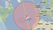
The air routes affected are A582, which goes from Jomalig island off the eastern coast of Mindanao to Japan’s Kyushu island via Miyako island; A590, which goes from Jomalig to just south of Tokyo; and R597, which feeds on to both preceding air routes from Calabarzon City, north of Manila (see map, below).
The message advises pilots to “exercise caution navigating airways A582, R597 and A590 that traverse a satellite launching falling area.” The launch time matches that provided to the IMO: 7am to noon local time (2200 to 0300 GMT) from April 12th to 16th.
The advisory is standard practice for any rocket launch that could impact civilian transportation. In announcing its rocket launch plans last week, North Korea said it has notified the International Civil Aviation Organization, the International Maritime Organization and the International Telecommunication Union.
The full “Notice to Airmen” (NOTAM) message is below:
B0372/12 NOTAMN
Q) RPHI/QRALW/IV/NBO/W /000/999/1716N12415E134
A) RPHI B) 1204112200 C) 1204160300
D) DAILY 2200-0300
E) EXER CTN WHEN NAVIGATING ON AIRWAYS A582, R597, A590 THAT
TRAVERSE SATELLITE LAUNCHING FALLING AREA BOUNDED BY
THE FLW COORD:
FM POINT
19 24 32N 123 54 26E
19 23 08N 124 45 13E
15 08 19N 124 46 15E
15 09 35N 123 45 27E
TO ORIGIN
F) SFC G) UNL
CREATED: 21 Mar 2012 09:56:00
SOURCE: EUECYIYN
And here’s the map:
View Larger Map